Earthmate GPS Receiver by DeLorme
Finally an Excuse to go Hiking
DeLorme's Earthmate GPS and Solus Pro software looked very promising. Finally, an excuse to take my Palm hiking and really do something with it! Unfortunately, this was not to be. The Earthmate is NOT a stand-alone item. Even with Solus Pro loaded on the Palm, you still have a considerable amount of work to do in front of the computer before the Earthmate's capabilities can be truly appreciated.
In case you don't already know, GPS or Global Positioning System, is a collection of satellites that orbit the earth.They allow users including the military and civilians to use the signals to triangulate. With this information, a GPS unit can determine where we are located on the earth to within a few feet (although for security, the military requires built in errors that cause the locations to be off by 50 ft. or more). That's the short, nontechnical, and quite possibly overly simplified explanation of GPS. Let's take a look at the Earthmate and see what it can do.
It Aint Plug and Play
In order to use the Earthmate at all, you need to have the Solus or Solus Pro software installed on your Palm. The next step is to get your maps and/or directions. To do this, you need to use Solus to access the Delorme web site and download the maps(driving directions can't be obtained through Solus) or use Street Atlas 7.0 to create your map and/or driving directions. In either case, there is an option to send the files to the Palm, however they are not automatically sent to the install tool. You need to do the extra step of opening the installer, finding the maps and directions and installing them manually. This is just one of the shortcomings of the software.
DeLorme advertises the Earthmate as 'satellite navigation for your car' and this is true. You really can't use the Earthmate as you would a traditional GPS to mark waypoints and plot locations that you would like to come back to at a later date. There just isn't any way to return to a plotted location. I don't know why this isn't possible. It certainly should be.
from the Palm directly, however since it only works while plugged into the Palm, you will drain your Palm batteries while using the Earthmate. The Earthmates batteries will last about 10 hours before they need to be replaced.
Software the Makes you Scratch Your Head
Once you get the software installed on the Palm and on your PC, you need to locate the map areas you need and then load them into your Palm. When you install Solus, an application is installed on your PC that will go to the DeLorme web site and download an appropriate map. You then install it on your Palm as you normally would. Using Street Atlas, you construct your map or route by inputting the address information and sending it to the Palm folder. You must manually install the maps and routes here as well. The map of my city, encompassing about 4 square miles (with the additional zoom level map) took up 131k on my Palm. Having several maps can really eat into your Palm's memory.
As a test, I tried using the Navigate screen to location across town. When I leave my neighborhood, I can go left or right and end up at the same intersection. Street Atlas gave me directions and the route started by going south then west. Because of traffic congestion, I usually go north then west and end up at the same place. Since I would ultimately end up at the same place in under a minute, I opted for my regular route. The minute I made the turn out of my driveway in a direction contraindicated by the Navigate screen I was done for. The Earthmate and/or Solus could not get me back on track even when I ended up traveling the predetermined route a couple of minutes later. To be fair, I then tried following the correct route and it worked flawlessly.
It is unbelievable that a GPS unit costing this much cannot do the simple task of tracking me from point A to point B, then run a reciprocal course back to A...not without a previously installed map of the proper area that is! Heaven forbid you travel off the edge of the map because when you do your Earthmate GPS is USELESS! Well, that's not entirely true, because you can mark a spot. Once you mark it, THEN it's useless because you can't do anything with that mark. It's not like a regular GPS where you can set it to mark a waypoint either manually or at set intervals, then return to any particular waypoint from any location.
The Bottom Line:
The Earthmate does what it says and it does it as accurately as any other GPS device. The problem is that it doesn't do simple tasks that other GPS units do. It's software, while adequate is not well thought out, poorly documented and in the long run, doesn't provide much more than what you can get at mapquest for free. If it's GPS you want, I recommend getting a handheld unit that is waterproof, floats, and does not need to be attached to the Palm. On the other hand, if you only plan on using it to drive city streets, and have the time to input the address information, download the routes and maps, and don't every think you are going to travel outside the bounds of the maps, then maybe the Earthmate is for you. I still think you are better off with a $20 Thomas Guide or Rand-McNally map. If you insist on have driving directions spelled out for you, use MapQuest. It's free and when you use Avantgo, you can download the map or directions right into your Palm.
The Eathmate GPS is available through DeLorme. The Earthmate Road Warrior bundle includes the Earthmate, adapter cable, Solus Pro and Street Atlas for $219.95.
What I like:
The GPS does do a decent job of tracking
Watching your progress on the map is cool
Maps and directions are thorough
What I don't like:
The GPS does only a decent job of tracking(not a good thing when it shows you on a differnent street than you are actually on)
Software is complex and not intuitive
Documentation is substandard.
Basic GPS features such as waypoints are not implemented.
Proprietary GPS requires pricey and limited proprietary software.
3 out of 5 Rating (only because it does work as advertised)

Finally an Excuse to go Hiking
DeLorme's Earthmate GPS and Solus Pro software looked very promising. Finally, an excuse to take my Palm hiking and really do something with it! Unfortunately, this was not to be. The Earthmate is NOT a stand-alone item. Even with Solus Pro loaded on the Palm, you still have a considerable amount of work to do in front of the computer before the Earthmate's capabilities can be truly appreciated.
In case you don't already know, GPS or Global Positioning System, is a collection of satellites that orbit the earth.They allow users including the military and civilians to use the signals to triangulate. With this information, a GPS unit can determine where we are located on the earth to within a few feet (although for security, the military requires built in errors that cause the locations to be off by 50 ft. or more). That's the short, nontechnical, and quite possibly overly simplified explanation of GPS. Let's take a look at the Earthmate and see what it can do.
It Aint Plug and Play
In order to use the Earthmate at all, you need to have the Solus or Solus Pro software installed on your Palm. The next step is to get your maps and/or directions. To do this, you need to use Solus to access the Delorme web site and download the maps(driving directions can't be obtained through Solus) or use Street Atlas 7.0 to create your map and/or driving directions. In either case, there is an option to send the files to the Palm, however they are not automatically sent to the install tool. You need to do the extra step of opening the installer, finding the maps and directions and installing them manually. This is just one of the shortcomings of the software.
DeLorme advertises the Earthmate as 'satellite navigation for your car' and this is true. You really can't use the Earthmate as you would a traditional GPS to mark waypoints and plot locations that you would like to come back to at a later date. There just isn't any way to return to a plotted location. I don't know why this isn't possible. It certainly should be.
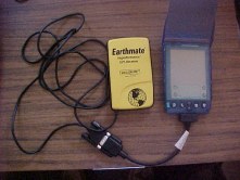 |
The Earthmate is housed in a yellow plastic case that is just slightly smaller than the Palm. A rather long serial cable about 6ft.) extends from the bottom. The cable is as long as it is because the Earthmate is intended to sit on the dash of your vehicle while the Palm is in the passenger seat (or your lap). The Earthmate seems to be originally designed to work with a laptop computer, and I think that it would really shine in that situation. The Palm compatibility really seems to be an afterthought. |
| You need a special interface cable to attach the Palm, but once attached, the Earthmate begins working immediately. There is no on/off switch to worry about. The cables attach firmly and I only had a few instances where I bumped the Palm or the Earthmate and the cables popped off. The Earthmate runs on 4 AAA batteries that are installed via a small door on the back of the device, so it doesn't draw power | 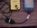 |
from the Palm directly, however since it only works while plugged into the Palm, you will drain your Palm batteries while using the Earthmate. The Earthmates batteries will last about 10 hours before they need to be replaced.
Software the Makes you Scratch Your Head
Once you get the software installed on the Palm and on your PC, you need to locate the map areas you need and then load them into your Palm. When you install Solus, an application is installed on your PC that will go to the DeLorme web site and download an appropriate map. You then install it on your Palm as you normally would. Using Street Atlas, you construct your map or route by inputting the address information and sending it to the Palm folder. You must manually install the maps and routes here as well. The map of my city, encompassing about 4 square miles (with the additional zoom level map) took up 131k on my Palm. Having several maps can really eat into your Palm's memory.
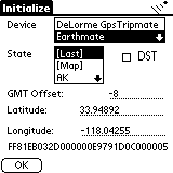 |
In order to begin using the Earthmate, you must first select the device and state that you are in. Set the daylight savings time if applicable and make sure your GMT offset is correct and you are all set to go. You will know your Earthmate is in contact with the satellites when you see a string of numbers across the bottom of the screen as well as in indicator in the upper right hand corner that shows either no device, searching for satellites, 2-D or 3-D. Make sure you check the DST(daylight savings time) box when appropriate. Your current latitude and longitude will be displayed on the screen. You need to be outdoors. The GPS has trouble finding the satellites when you are inside or under heavy cover. |
| The Map screen shows the current map you have loaded into Solus and if the Earthmate is plugged in and in contact with the satellites, a crosshair will show you your current location. When you download your maps into the Palm, you have a choice of loading a general map or a detailed map. When you enter the area of detail, the map zooms in to show precise street names and locations. It's pretty neat to see your progress as you travel down a street and turn at an intersection, however due to the offset in GPS, sometimes you might find that your location shows you on the street NEXT to the one you are actually on. This is not good if you are using the map to navigate to an actual location. | 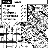 |
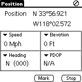 |
The Position screen shows you your exact location at any given time. In this screen shot, I have the default Speed, Elevation, Heading, PDOP(Position Dilution of Precision) displayed however you can also choose Time, Date, Tripometer, Time to next Turn among others. You can set the preferences to start on any of the screens when the program is run, and you can check Route Warning so that you will be notified by a beep when a course change is upcoming. Additionally, you can log your route at selected intervals starting at one hour. This info is then downloaded to the desktop for use with your mapping software. |
As a test, I tried using the Navigate screen to location across town. When I leave my neighborhood, I can go left or right and end up at the same intersection. Street Atlas gave me directions and the route started by going south then west. Because of traffic congestion, I usually go north then west and end up at the same place. Since I would ultimately end up at the same place in under a minute, I opted for my regular route. The minute I made the turn out of my driveway in a direction contraindicated by the Navigate screen I was done for. The Earthmate and/or Solus could not get me back on track even when I ended up traveling the predetermined route a couple of minutes later. To be fair, I then tried following the correct route and it worked flawlessly.
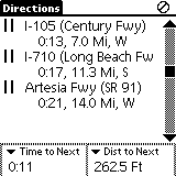 |
The directions screen is similar to the Navigate screen in that each leg of your trip is shown and highlighted, however the Directions screen shows several at a time and marks where you are. On the left, solid circles represent your start and stop while a dotted line indicates a local road. A solid double line represents a highway or interstate and a solid thick line is a state route. Toll roads are also indicated by a dollar sign. As you can see from the screen shot on the left, my route took me along highways. |
It is unbelievable that a GPS unit costing this much cannot do the simple task of tracking me from point A to point B, then run a reciprocal course back to A...not without a previously installed map of the proper area that is! Heaven forbid you travel off the edge of the map because when you do your Earthmate GPS is USELESS! Well, that's not entirely true, because you can mark a spot. Once you mark it, THEN it's useless because you can't do anything with that mark. It's not like a regular GPS where you can set it to mark a waypoint either manually or at set intervals, then return to any particular waypoint from any location.
The Bottom Line:
The Earthmate does what it says and it does it as accurately as any other GPS device. The problem is that it doesn't do simple tasks that other GPS units do. It's software, while adequate is not well thought out, poorly documented and in the long run, doesn't provide much more than what you can get at mapquest for free. If it's GPS you want, I recommend getting a handheld unit that is waterproof, floats, and does not need to be attached to the Palm. On the other hand, if you only plan on using it to drive city streets, and have the time to input the address information, download the routes and maps, and don't every think you are going to travel outside the bounds of the maps, then maybe the Earthmate is for you. I still think you are better off with a $20 Thomas Guide or Rand-McNally map. If you insist on have driving directions spelled out for you, use MapQuest. It's free and when you use Avantgo, you can download the map or directions right into your Palm.
The Eathmate GPS is available through DeLorme. The Earthmate Road Warrior bundle includes the Earthmate, adapter cable, Solus Pro and Street Atlas for $219.95.
What I like:
The GPS does do a decent job of tracking
Watching your progress on the map is cool
Maps and directions are thorough
What I don't like:
The GPS does only a decent job of tracking(not a good thing when it shows you on a differnent street than you are actually on)
Software is complex and not intuitive
Documentation is substandard.
Basic GPS features such as waypoints are not implemented.
Proprietary GPS requires pricey and limited proprietary software.
3 out of 5 Rating (only because it does work as advertised)